Step 4: Specify Map Options
This step configures the size of the map on your page, as well as the optional controls that can be included in your map to assist the end user. The preview pane at the bottom updates with an example of each control option when enabled in this step to assist you in configuration.
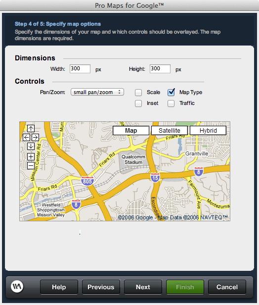
Width: The width of the map in pixels as it is displayed on the page.
Height: The height of the map in pixels as it is displayed on the page.
Pan/Zoom: Offers options for the availability and extent of the tools provided in the map that allow you to move in any display direction relative to the original location, or zoom in and out.
Scale: Enables or disables the display of the map scale to assist users in determining distance.
Map Type: Enables or disables the display of additional map display options, including Satellite and a Hybrid, which is a combination of Satellite and Street mapping.
Inset: Enables or disables the display of a high altitude display of the map in the lower right corner to provide a higher level context of the location detailed in the map to the viewer.
Traffic: Displays Google's real-time, color-coded traffic display overlaid on the map.
Dimensions
Specifies the size of the map as it appears on your page.Width: The width of the map in pixels as it is displayed on the page.
Height: The height of the map in pixels as it is displayed on the page.
Controls
Controls are optional elements that can be overlaid on the map to assist people in using it. When a control is selected or checked, the preview image updates accordingly to display an example of the given control option.Pan/Zoom: Offers options for the availability and extent of the tools provided in the map that allow you to move in any display direction relative to the original location, or zoom in and out.
Scale: Enables or disables the display of the map scale to assist users in determining distance.
Map Type: Enables or disables the display of additional map display options, including Satellite and a Hybrid, which is a combination of Satellite and Street mapping.
Inset: Enables or disables the display of a high altitude display of the map in the lower right corner to provide a higher level context of the location detailed in the map to the viewer.
Traffic: Displays Google's real-time, color-coded traffic display overlaid on the map.