Step 2: Enter Addresses Or Coordinates To Map
In this step, all locations to be mapped are entered and listed in the display pane. You have the option of specifying a location either by address or by coordinates (latitude and longitude).
In addition, location information can be specified statically as individual listings in the display pane, or by specifying dynamic data. Return multiple addresses for a single listing in the display pane using data bindings, including direct support for recordsets available on the page.
When an address is selected from the display pane, its information populates the configuration fields, allowing you to modify it as necessary.
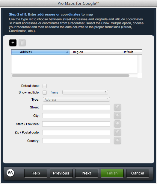
 Add button: Creates a new location entry in the display pane to configure for your map.
 Remove button: Removes a location entry selected within the display pane.
Default destination: Determines the address the map will be centered on and has the info window displayed for upon first viewing the map. If no address is marked as the default, the map will not have an info window opened on load of the page and the map will be centered on the last entered address. If a recordset listing is selected as the default, the first address record returned will be treated as the default address.
Show multiple: Enables using an available recordset on the page to return location information for the given listing. Use the data bindings for each location element to map database columns from the recordset selected.
This information needs to be as detailed as possible in order to ensure that a map is generated correctly. You may need to test to determine that your specified addresses get mapped correctly, either through the extension, or by visiting Google Maps online to enter and test a given address.
In addition, location information can be specified statically as individual listings in the display pane, or by specifying dynamic data. Return multiple addresses for a single listing in the display pane using data bindings, including direct support for recordsets available on the page.
When an address is selected from the display pane, its information populates the configuration fields, allowing you to modify it as necessary.
Location panel
Lists all locations included in your map. Shows the configured address or geo-location, the regional data for a given address, which address is the default to display the address in the map, and whether a listing is looping through a recordset to return address records for display. When a specific listing is selected, the controls below the pane update the configuration data associated to the listing.Default destination: Determines the address the map will be centered on and has the info window displayed for upon first viewing the map. If no address is marked as the default, the map will not have an info window opened on load of the page and the map will be centered on the last entered address. If a recordset listing is selected as the default, the first address record returned will be treated as the default address.
Show multiple: Enables using an available recordset on the page to return location information for the given listing. Use the data bindings for each location element to map database columns from the recordset selected.
Type
Select whether to use an address or coordinates to specify a location to be mapped. Specify the details for either criteria in a given listing.Address
In address mode, the street, city, state, zip, and country fields are available to either specify address information directly, or use data bindings to map this information dynamically.This information needs to be as detailed as possible in order to ensure that a map is generated correctly. You may need to test to determine that your specified addresses get mapped correctly, either through the extension, or by visiting Google Maps online to enter and test a given address.